CapeLinks Cape Cod Massachusetts
Cape Cod: Articles: Interesting, Places, Sandwich -- post an article
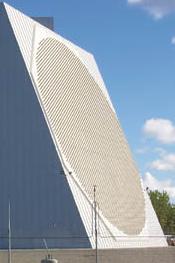
 Pave Paws Radar Station at Otis AFB
The radar, developed by Raytheon, is used primarily to detect and track sea-launched (SLBM) and intercontinental ballistic missiles (ICBMs). PAVE PAWS radars are located at Cape Cod Air Force Station, Massachusetts, Beale AFB, California, and Clear Air Force Station, Alaska. PAVE is an Air Force program name, while PAWS stands for Phased Array Warning System.
 The system also has a secondary mission of Earth-orbiting satellite detection and tracking. Information received from the PAVE PAWS radar systems pertaining to SLBM/ICBM and satellite detection is forwarded to the U.S. Strategic Command’s Missile Correlation (formerly Missile Warning) and Space Control Centers at Cheyenne Mountain Air Station, Colorado. Data is also sent to the National Military Command Center and to U.S. Strategic Command’s Command Center at Offutt AFB, Nebraska.
The installation occupies approximately 100 acres of land on Flat Rock Hill in the northeastern portion of the Massachusetts Military Reservation (MMR) on upper Cape Cod. The installation at Cape Cod AFS was the first of its type to be built and operated. The installation was completed in 1978 and activated as the 6th Missile Warning Squadron on October 1, 1979. On May 1, 1983, the unit was transferred to the 21st Space Wing of Air Force Space Command as the 6 SWS.
Pre 9/11, we used to go deer hunting all over the base and I have been within a couple hundred yards of the PAVE PAWS site. That thing is huge! The picture does not do it justice. I remember that day really well because it was really cold. Although my hands and feet were freezing, I felt really warm inside for some strange reason. Zoomed in satellite view may be distorted for National Security reasons. ???
• tell-a-friend • link to this post •
Map - (click marker for driving directions)view large maps: aerial, birdseye, street, satellite, hybrid, topo & aerial | view all mapped places
|
|
Categories: Interesting, Places, Sandwich
Keywords: radar, air force, military, otis, places
Comments:
There were no passengers on any of the planes that were not ‘hijacked’ by any ‘Arabs’. The perpetrators were all given fast-track visas through the American Embassy in Jeddah, however, which as the issuing person exclaimed “Never happens!”
If you look at each of the mens’ pictures, they are all passport pictures. Some of the accused are still alive.
If you would read the Northwoods document, now declassified, you will see exactly what did happen that horrendous day, when Cheney and his buddies murdered thousands of innocent Americans to get their war/oil.
Posted by NW from earth on 05/15/09 at 02:46 AM | #
Dear Mr Cheatham in Louisiana,
With all due respect, someone has fed you a load of bull.
The last time an outside entity crossed put border and caused loss of life was when the Pancho Villa gang rode into Columbus New Mexico, killed 17 people in cold blood, then rode back into Mexico (current turf wars between drug cartels in the border cities of Texas not withstanding).
General Pershing was sent with a small detachment was sent to give chase. Sadly, that’s all they were able to do, as the USA didn’t offer them any kind of reinforcements whatsoever. Eventually Pershing and his men had to return by railroad cars.
In the meantime, General Pershing’s wife (and family?) were killed in the 1906 earthquake in San Fransicso.
There were NO ‘Arabs’ on any of the four planes which did NOT hit anything, especially WTC7.
Please Research Able Danger (Kurt Weldon, bless him); read up on which US Senators were sent anthrax from Ft Detrick, and why, etc.
Please read the Northwoods document.
Read about a true patriot named General Smedley Butler.
Look up Project Mockingbird (and a similar project even older than that!)
Read what Thermite and THERMATE is, and what it does.
Rumsfeld said a missile was fired in Pennsylvania.
EVERYONE in the government is lying to you. If you go to youtube, to George Carlin’s last monologue, he will tell you same thing I am.
Why was Paul Wellstone murdered?
Why did Gary Webb ‘shoot himself’(Dark Alliance’)?
Subscribe to any newspaper from outside the the US. The Financial Times, Observer and Guardian are some great sources to begin with.
The ONLY people in this country that will NOT lie to you, is me, Mike Gravel, Dennis Kucinich, Dr Ron Paul, Cynthia McKinney, Karen Kwiatkowski, whistle-blowers (Sibel Edmonds), Cele Castillo, ANY 911 truther, etc.
Do NOT believe anything the Pentagon tells you.
Please open your eyes.
Our once great nation is in it’s death throes!
Learn what hunker down means - fast.
Bless you.
Just a response to the PAVE PAWS article, in particular concerning the “really warm feeling” the writer spoke about. I doubt the feeling came from the radar. Perhaps the effect of some cognac? The reason is, even though the energy from the PAVE PAWS is directed close to the horizon to detect a target as far away as possible, it can’t be too low or ground clutter will be received into the radar. There are some PAR radars designed to operate with ground clutter but typically they are tactical system radars that must find real targets flying at just above ground level such as cruise missiles. Those radars can “see” through ground clutter. Even then the radar energy would be directed high enough that someone standing in front of the radar would not be getting the dose of energy necessary to “warm up the body”. I worked on one system that used a calibration mode where the energy was directed low enough to hurt a human body if it was standing in front of it. The beam steering circuits directed the energy down low while readings were taken. The power levels that were used was what made it dangerous to be in front of the radar during calibration. It is not safe to stand in the field of any high power radio or radar transmitter. There should be signs or a fence outside the area considered harmful to the human body to keep people from getting hurt.
Posted by Rene from nebraska on 12/22/09 at 05:24 AM | #
My Father used to work there. I went there when I was a kid. It was awesome then and still is awesome!!!!
Posted by Joseph from Florida on 02/26/10 at 05:27 PM | #
Talk about a load of bull. Congrats nw for being duped by those who get off on conspiracy theories and how many lost souls they can collect. I’ve read a lot of such bs, but I have to admit, yours ranks right up there with the best of them. Please keep us informed of other works of fiction you indulge in.
Posted by Michael from Louisiana on 10/13/11 at 08:55 PM | #
Related Posts: are tagged with radar, air force, military, otis, places
- Gaynor & Dent Consignments South Dennis
- Ferry to Nantucket Island
- Rockwell Kent and the Cape Cinema Mural
- Walk The Streets of Barnstable Village-History/Haunted
- Bassett’s Wild Animal Farm
| Coastal Waters & Offshore Marine Forecasts >>
Read More About Cape Cod


For our safety from SLBM/ICBM. more and more such systems will have to be tolarated. Currently there are two operated PAVE PAW system and people living in a certian radius of them will have to indure there operations.
At the present time in California at Beale AFB, amateur radio operators operating repeater on 440 MHZ radio band are having to lower the power of their privately owned repeater sites around the radar site because of interference from the repeaters. The Ham operators of these 440 repeaters in California near Beale AFB are working with the Air Force to not interfer with the operation of the PAVE PAW radar.
They are working with the Amateur Radio Relay League, USAF, and FCC, to accomplise the required needs of the USAF. In many cases they have had to either lower there output power of the repeaters or either move the antennas or repeaters of satisfy the FCC, and Air Force.
All this is a sacrifice for the Defense of the USA.
Jim